
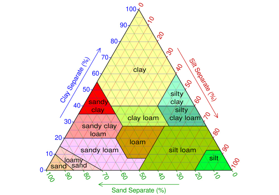
The USDA soil texture triangle is a standardized graphical classification tool developed by the United States Department of Agriculture to categorize soil based on the relative percentages of sand, silt, and clay it contains. It is widely used in stormwater management, soil science, and engineering to determine soil texture class from laboratory or field data.
The triangle is arranged as a three-axis diagram, where each side represents one of the three particle size fractions, expressed as a percentage from 0 to 100. The bottom axis corresponds to sand content, the left axis to clay, and the right axis to silt. Each side is scaled so that any point within the triangle represents a unique combination of sand, silt, and clay that together sum to 100 percent.
To use the triangle, the percentages of sand, silt, and clay in a soil sample are plotted by following grid lines associated with each axis. The intersection of these three values falls within one of several defined regions, each representing a soil texture class such as loam, sandy loam, silty clay, or clay loam. These classes are standardized and provide a consistent way to describe soil physical properties.
In stormwater management, the USDA soil texture triangle is important because it allows practitioners to quickly infer how a soil will behave hydraulically and physically. For example, soils that plot in sandy regions generally have high infiltration rates and low water holding capacity, while soils in clay-rich regions tend to have low permeability and higher runoff potential. The classification also helps guide the design and suitability of practices such as infiltration basins, bioretention systems, and drainage infrastructure.
Because it provides a uniform and reproducible method for classifying soils, the USDA soil texture triangle is a foundational tool for evaluating site conditions, predicting stormwater movement, and selecting appropriate management strategies.
Image attribution: cmglee, Mikenorton, United States Department of Agriculture, CC BY-SA 4.0, via Wikimedia Commons