
A hydrograph is a graphical representation of the rate of flow (discharge) versus time at a specific point in a drainage system, such as a stream, culvert, storm sewer, or outfall. In stormwater management, the hydrograph is a fundamental tool used to describe how a watershed responds to a precipitation event, illustrating the timing, magnitude, and duration of runoff.
The vertical axis of a hydrograph represents discharge, typically expressed in cubic feet per second (cfs), while the horizontal axis represents time. The shape of the hydrograph reflects how quickly runoff is generated, how high the peak flow becomes, and how long it takes for flows to return to pre-storm conditions.
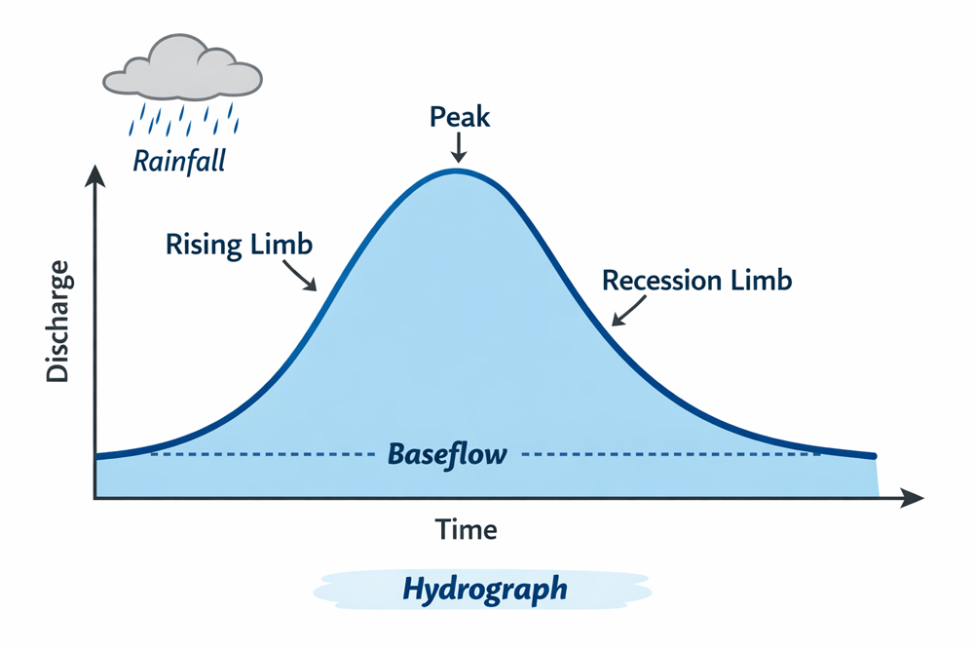
A typical stormwater hydrograph consists of several key components. The rising limb represents the increasing flow as runoff begins and accumulates in the drainage system following the onset of rainfall. The slope of the rising limb is influenced by factors such as rainfall intensity, impervious cover, and the efficiency of the drainage network. The peak discharge is the highest point on the hydrograph and represents the maximum flow rate generated by the storm event. This value is critical for sizing stormwater infrastructure and assessing flood risk.
Following the peak, the recession limb (or falling limb) shows the gradual decline in flow as runoff diminishes and stored water drains from the watershed. The shape and length of the recession limb are influenced by storage within the watershed, including soil moisture, surface depressions, and detention facilities. The baseflow portion of the hydrograph represents the normal, pre-storm flow in a stream, typically sustained by groundwater inputs, and is most relevant in natural or perennial stream systems.
Hydrographs are directly influenced by watershed characteristics. Smaller or highly urbanized watersheds tend to produce “flashy” hydrographs, with steep rising limbs, high peaks, and short durations due to rapid runoff from impervious surfaces. In contrast, larger or more vegetated watersheds typically produce flatter, more extended hydrographs with lower peak flows due to greater infiltration, storage, and slower runoff routing.
Hydrographs are often paired with a hyetograph, which is a graph of rainfall intensity over time. Together, these tools allow engineers to analyze the relationship between rainfall input and runoff response. This relationship is central to hydrologic analysis and is used to design systems that manage peak flow, reduce flooding, and protect downstream channels.
In stormwater design, hydrographs are used to evaluate how different management practices, such as detention basins or bioretention systems, modify runoff behavior. For example, a detention basin is designed to attenuate the hydrograph by reducing peak discharge and extending the duration of flow, thereby minimizing downstream impacts.
A hydrograph is a time-based depiction of how stormwater flow changes during and after a rainfall event. It provides critical insight into watershed behavior and is an essential tool for designing, analyzing, and managing stormwater systems.