

The Soil Conservation Service Curve Number (SCS Curve Number, or CN) is a dimensionless empirical parameter used to estimate direct stormwater runoff from a rainfall event based on watershed characteristics, including soil type, land use, land cover, and antecedent moisture condition. It was developed by the United States Soil Conservation Service, now known as the Natural Resources Conservation Service, and remains one of the most widely used methods in hydrologic design and stormwater management.
At its core, the curve number represents the runoff potential of a given area on a scale from 0 to 100. Lower values indicate high infiltration capacity and low runoff potential, such as in forested areas with well-drained soils, while higher values indicate low infiltration and high runoff potential, such as in paved or heavily compacted urban areas. A curve number of 100 corresponds to a condition where nearly all rainfall becomes runoff, with negligible infiltration.
The method is based on a simplified water balance relationship that estimates direct runoff depth from total precipitation. It assumes that runoff begins only after a certain amount of initial abstraction is satisfied, which includes interception, surface storage, and early-stage infiltration. Once this initial abstraction is exceeded, additional rainfall contributes to runoff according to a nonlinear relationship governed by the curve number.
A key parameter derived from the curve number is the potential maximum retention, often denoted as S, which represents the maximum amount of water the soil can retain after runoff begins. This relationship is commonly expressed as:
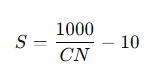
where S is in inches. Higher curve numbers result in lower storage capacity and thus greater runoff.
The SCS Curve Number method also explicitly incorporates antecedent moisture condition (AMC), allowing adjustments to reflect whether soils are dry, average, or saturated prior to a storm event. This adjustment is critical, as wetter soils produce significantly more runoff for the same rainfall depth.
Soils are categorized into Hydrologic Soil Groups (HSGs), typically labeled A through D, based on their infiltration rates and drainage characteristics. Group A soils have high infiltration rates and low runoff potential, while Group D soils have very low infiltration rates and high runoff potential. Land use categories, such as residential, agricultural, or forested, are combined with these soil groups to assign appropriate curve numbers from standardized tables.
In practice, the SCS Curve Number method is widely used for stormwater design, flood estimation, and watershed modeling, particularly for small to moderately sized drainage areas. It is favored for its relative simplicity, minimal data requirements, and adaptability to a wide range of land use conditions. However, it is also important to recognize its limitations, as it is an empirical method based on generalized assumptions and may not fully capture complex hydrologic processes in all settings.
In summary, the Soil Conservation Service Curve Number is a standardized numerical representation of a watershed’s runoff potential, used to estimate how much rainfall will become surface runoff based on soil properties, land use, and prior moisture conditions.